
Trace a San Benito Street Address
Begin a San Benito street directory search with the physical address, not a surname. The address can lead to a Cameron CAD account, then to a PID or GEO ID, a legal description, and a mapped parcel. That sequence keeps the street research tied to one piece of land even when an owner name, mailing label, or street spelling changes. A CAD owner field identifies an appraisal-account owner. It does not establish every person connected with the location.
- Enter the address in Cameron CAD Property Search and save the physical address, PID or GEO ID, owner field, and legal description shown for the account.
- Open the location in Cameron CAD Map Search. Check the parcel position, its street segment, and nearby parcel boundaries before comparing any names.
- Use the legal description, lot/block, or book and page reference to locate a recorded transfer. A person named in an instrument may be a buyer, seller, heir, or other party rather than a current resident.
- For a confirmed person, Texas MVP is a person-first lookup. It is not an open browse tool for an entire San Benito street, and protected information remains withheld.
- For an older date, ask the Historical Society, UT Briscoe, or TSLAC about an applicable directory issue. No official shelf run of local reverse directories was verified, so confirm the issue before relying on it.
Keep a short research log with the address used, PID/GEO ID, legal description, source date, and the kind of record returned. That makes it easier to distinguish a current parcel clue from an older street directory entry.
San Benito Street Directory Parcel Keys
Street names are useful, but the parcel keys hold a San Benito address trail together. CAD separates the physical, or situs, address from a mailing address used for appraisal and tax correspondence. A mailing address can be outside the city and is not a statement about where a person is present. The legal description carries the lot, block, subdivision, or metes-and-bounds language that a deed uses. It is often the safer bridge when an old document omits a modern street number.
- Parcel
- A defined piece of land or account area used in the appraisal and mapping systems. Its PID or GEO ID helps stabilize a San Benito street search.
- Situs address
- The physical location of the parcel. It belongs in a street-by-street record, unlike a tax mailing address that may point elsewhere.
- Plat
- A recorded map of a subdivision or lots. A plat can connect a lot and block to the street layout used in a deed search.
- Criss-cross directory
- An address-arranged directory that can connect a street number to a dated subscriber or business listing when an actual volume is available.
San Benito also sits within city, county, and ETJ mapping systems. Compare city Planning maps and county mapping when the jurisdiction is uncertain, rather than assuming a mailing label settles the question.
Cameron CAD for San Benito Streets
The CAD property search is the most direct San Benito street directory starting point because its FAQ confirms four ways to find an account. Address and PID searches are usually better for a named street, while an owner-name search can locate possible parcels for a known person. The static material does not confirm partial-match rules, exact address format, or which field a live screen requires. Treat a no-result as a reason to try the alternate parcel key, not as proof that the location has no record.
| CAD field | Type | Required | Use and format note |
|---|---|---|---|
| PID number | Text | No, one search mode | Exact format was not published in the static FAQ. |
| GEO ID number | Text | No, one search mode | Use as a stable account key; exact format was not published. |
| Address | Text | No, one search mode | Physical or situs address; partial-match behavior was not confirmed. |
| Owner name | Text | No, one search mode | Owner-name search is confirmed; name order and partial behavior were not published. |
| Search | Button | Not stated | The dynamic control label was not captured in the static material. |
When the online account is not enough, CAD accepts public-information requests by mail, fax, email, or in person. Its request form asks for the owner, physical address, legal description, and maps as appropriate. CAD lists a notice period when production will take more than 10 working days and a cost estimate for a request expected to exceed $40.
Map a San Benito Street Segment
A mapped street segment adds the context a text result cannot show. The county CivicAccess guide describes Address & Parcel Search with a partial address and autocomplete result, followed by Zoom To/Add. Once the target parcel is on screen, zoom out just enough to see the adjacent parcel polygons. Follow a neighboring polygon back to its CAD account instead of guessing from a nearby street number.
The guide also documents point, line, polygon, rectangle, and circle drawing tools, plus transform, reshape, undo, redo, delete, aerial/base maps, and zoom. Parcels and base-map tools are confirmed. Do not assume a particular zoning, flood, or district layer is active unless the live map displays it. County GIS/Transportation at 1390 W Expressway 83 in San Benito can provide map printing and road, development, and subdivision mapping when the online view needs a local follow-up.
Map tip. Save the PID/GEO ID and legal description before moving to the deed index, because map labels and street spellings may not match the wording in an older instrument.
San Benito Street Directory Record Coverage
Several sources accept an address or parcel clue, but they answer different questions. The San Benito street directory is strongest when each result is labeled by what it actually records: ownership, parcel geometry, a recorded transfer, an inspection, or a dated historical listing. The table separates those roles and preserves the access route when an online search is unavailable.
| Address record | San Benito keeper | Street-level evidence | Access route |
|---|---|---|---|
| CAD appraisal account | Cameron CAD | Owner, PID/GEO ID, situs and mailing distinction, appraisal context | Property search/map or data and public-information request |
| GIS parcel map | CAD, county GIS, city Planning | Parcel geometry, adjacent parcels, road and jurisdiction context | Map viewer, map printing, and Planning maps |
| Deed or official record | Cameron County Clerk | Grantor, grantee, legal description, instrument date, book/page, liens and plat-related filings | Current or historic portal, clerk counter, or copy request |
| Inspection or permit | County CivicAccess or city Building | Address, case or permit, inspection status and dates | County portal; city office or Public Information Act request |
| Code case | San Benito Code Enforcement | Complaint, notice, citation, cleanup, or lien history where released | Address-and-date request through the city, no public index located |
| Historical directory | UT Briscoe, TSLAC, Historical Society | Dated subscriber, occupant, or business clue | Catalog, reading room, appointment, or remote research request |
Cameron County Official Records advanced search supplies party, date, document, book, volume, page, lot, block, legal-description, and OCR fields that can bridge an address to an instrument.
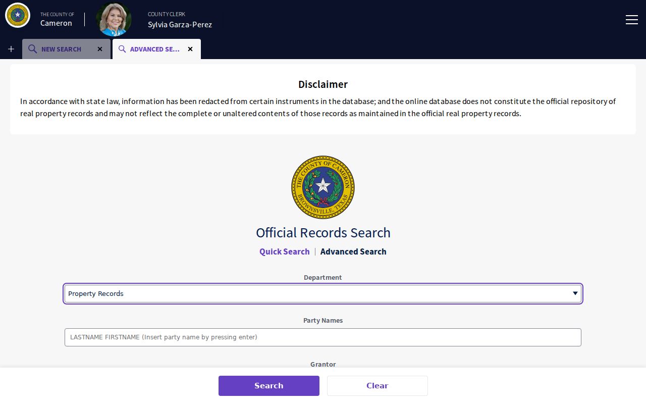
The lot, block, and legal-description controls are especially useful when a street name has changed form or is absent from a record.
Follow a San Benito Street Deed Chain
A deed chain traces recorded transfers for the same legal description. After CAD identifies the current parcel, use the present Official Records portal for a recent instrument and the historic index for older entries. In a backward search, the seller named in a purchase deed becomes the next person to find as an earlier grantee. Record the grantor, grantee, recording date, instrument type, book/volume/page, legal description, and whether an image is linked.
The Cameron historic deed index offers Type, Year, Parties, Last Name, First Name, Book, Volume, and Page controls for index books spanning 1830 through 1968.
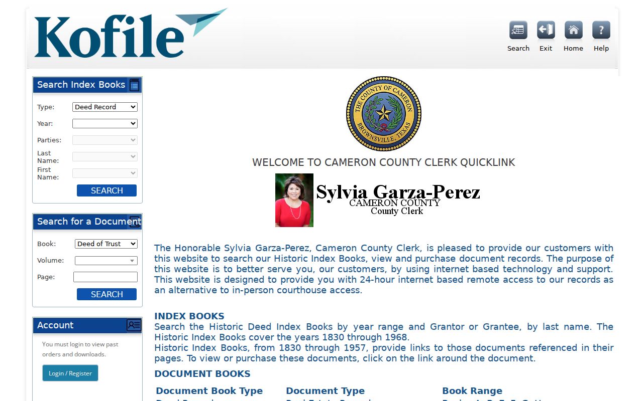
Linked documents are described for much of the 1830 through 1957 range. When an image is missing or the index ends, ask the County Clerk or San Benito Records Management for the relevant book or copy rather than assuming the online result is complete.
San Benito Street Permits and Code Records
Permit and inspection records can date changes at a San Benito address without proving a current household. County CivicAccess accepts case number, address, or inspection type. Its documented result fields include inspection number, type, address, status, case type, case number, reinspection, and requested, scheduled, and completed dates. Location, contacts, checklist, fees, attachments, previous inspections, and additional information appear as documented tabs, although public availability can vary.
The city lists many permit and inspection categories, but no public city permit or code-case index was located. Send the City Secretary a Public Information Act request that identifies the address, approximate date range, record category, and desired format. Code Enforcement describes complaints, notices, citations, cleanups, and liens, so an address-specific request is more useful than a broad name search.
Historic San Benito Street Clues
Historical street research needs dated layers. UT Briscoe verifies a regional Rio Grande Valley Telephone Directory issue run from 1945 through 2005, but it does not verify a San Benito-only reverse-directory shelf. The San Benito Historical Society holds business directories, tax rolls, maps, people files, newspapers, yearbooks, and cemetery records. Ask which issue or address arrangement is actually available before treating a subscriber clue as a street-level result.
For early local context, UNT has digitized San Benito Light issues from 1914 through 1925 with page images and OCR. Search surname and address variants, then inspect the page image because OCR can misread names. The archival collection routes are also summarized in the San Benito Directory Book.
Limits of a San Benito Street Directory
A parcel account does not list every person associated with an address. A deed is evidence of a recorded conveyance, not a continuous presence record. A voter result is a registration record and may be protected, suppressed, stale, or connected to a different address. Utility accounts and DMV information are not public street-search routes, and Texas confidentiality rules can restrict voter, court, vital, juvenile, and protected-address material.
Lawful use. Use San Benito address records for family history, estate research, property questions, and civic curiosity. Do not use them to stalk, harass, threaten, or expose a protected person.
San Benito Street Research Geography
San Benito has a practical records geography. CAD is at 2021 Amistad Drive, while County GIS/Transportation and the County Clerk branch are at 1390 W Expressway 83. Records Management is housed at the Joe G. Rivera/Aurora De la Garza County Annex in San Benito. Court and Elections counters are in Brownsville, so a property or historic-book question should not be routed to a court counter by mistake. Match the street record to the office that keeps it.
That local split also explains why a parcel trail may require both an online search and an in-person follow-up. Preserve the parcel key, instrument reference, and request date so the next office can locate the same San Benito street record.